

Real-time SigConv (Significant Convection)
|
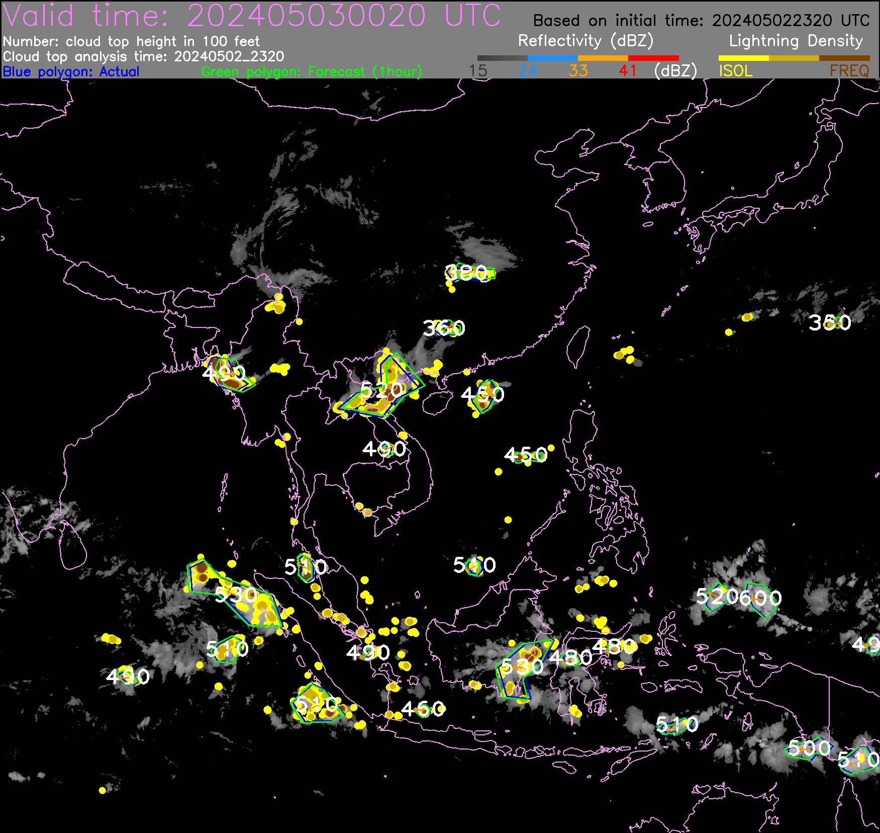
Significant convection presents imminent threats to in-flight aircraft for the associated hazards of lightning, turbulence, icing, rain and hail, etc. Limited by the range and coverage of on-board weather radar, pilots may not have a complete picture of the distribution and short-term evolution of convective systems within their intended flight path. The product shown here uses multiple channels, high resolution meteorological satellite data and real-time global lightning data to automatically identify and nowcast the hazardous areas of significant convection for aircraft's avoidance. More details of the satellite-based algorithm can be found in the paper: Development of Satellite Reflectivity Retrieval Technique for Tropical Cyclone Rainfall Nowcasting.
|
Real-time ICI (Ice Crystal Icing)
|
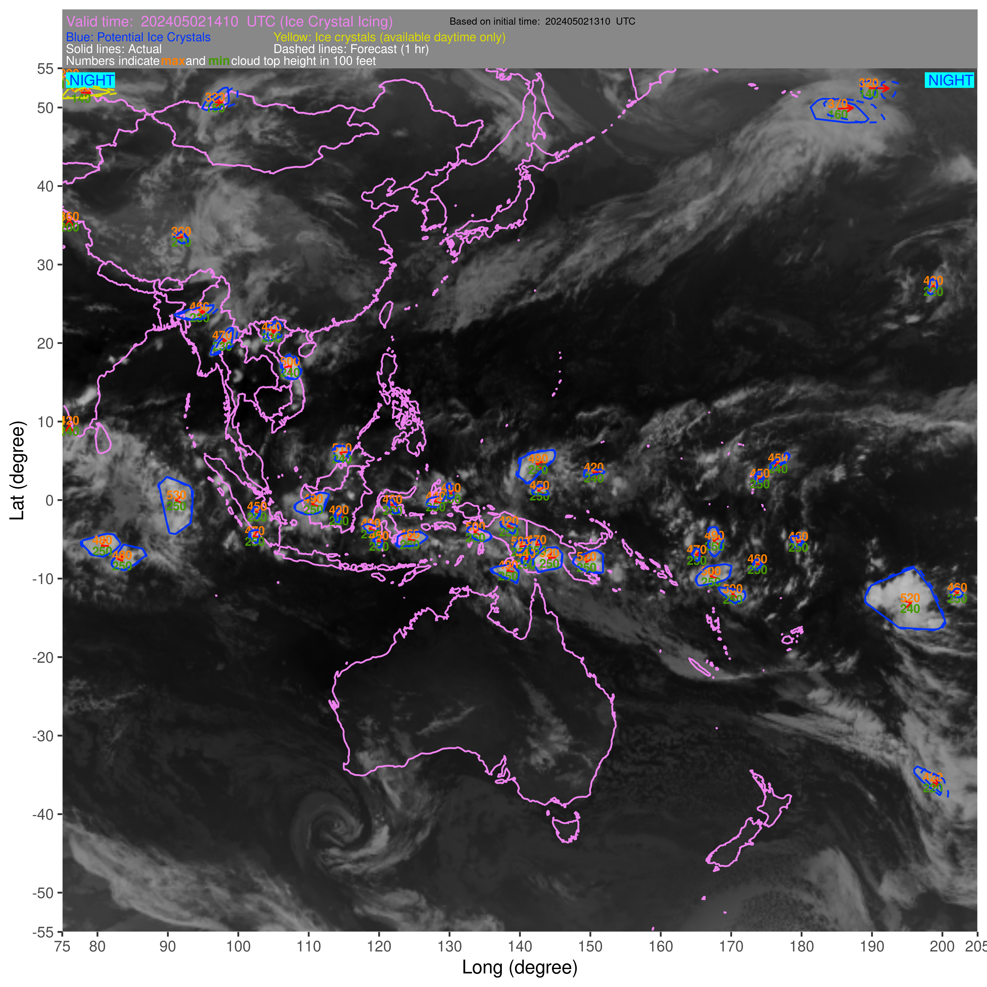
At the core of deep convection, small ice crystals may be thrown upward by the strong updrafts to very high altitude. As aircraft passing through regions of dense high altitude ice crystals, which might be undetected by aircraft radar, these small ice crystals may form a thin ice layer on the engine blades and cause the engine to lose power. This phenomenon is known as ice crystal icing (ICI) or engine icing. The product shown here uses multiple channel, high resolution meteorological satellite data to automatically detect and nowcast the hazardous areas which may have high potential of ICI for aircraft's avoidance.
A blue polygon in the ICI product image encompasses the area with occurrence of potential ice crystals due to deep convective activity of high clouds. It fulfills the following threshold criteria (in unit of degrees Kelvin, K) based on the Advanced Himawari Imager (AHI) channels : Band-13 (around 10.4 micrometres) brightness temperature of less than 243 K and the difference between the brightness temperatures of Band-12 (around 9.6 micrometres) and Band-13 within a range of 6.5 K and 19 K.
A yellow polygon depicts the area with potential ice crystals due to small ice particles for very cold cloud tops (and available only in daytime) with the criteria (in unit of degrees Kelvin, K): AHI Band-13 (around 10.4 micrometres) brightness temperature of less than 243 K and the difference between the brightness temperatures of Band-7 (around 3.9 micrometres) and Band-13 of more than 50 K.
The selection of the above thresholds has also referred to the observations from commercial aircraft flight data in the study to develop the ICI algorithm. More details of the algorithm to detect and nowcast the areas with occurrence of high potential of ICI as described above can be found in the following reference:
Y.L. Ng, H.F. Law, J.C.W. Lee, K.K. Hon, L.O. Li, and P.W. Li, 2017: Satellite Detection and Nowcasting High-altitude Ice Crystal, WMO Aeronautical Meteorology Scientific Conference, 6-10 November 2017, Toulouse, France (paper and presentation).
|
ATNS (Aviation Thunderstorm Nowcasting System)
|
ATNS is a nowcasting system tailored for aviation. It provides forecast of radar echoes at 6 minute time steps for the next 1 hour, and it is updated rapidly at 6 minutes. It will also highlight when a significant part of the air space is being or is expected to be affected by convection. The design goal of the system is to assist with the tactical decision making for ATC.
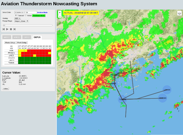
The ATNS frontend built by modern WEB and GIS technology
|
ATLAS (Airport Thunderstorm and Lightning Alerting System)
|
The Airport Thunderstorm and Lightning Alerting System (ATLAS) is developed to support the Red and Amber lightning alerts at Hong Kong International Airport (ICAO code: VHHH). It has proved to be an improvement over the earlier system and contributed towards minimising the risk of lightning to ground staff when working under these conditions. Tracking the movement of radar echoes and lightning activities, the system forecasts the time when lightning is expected to affect the airport.
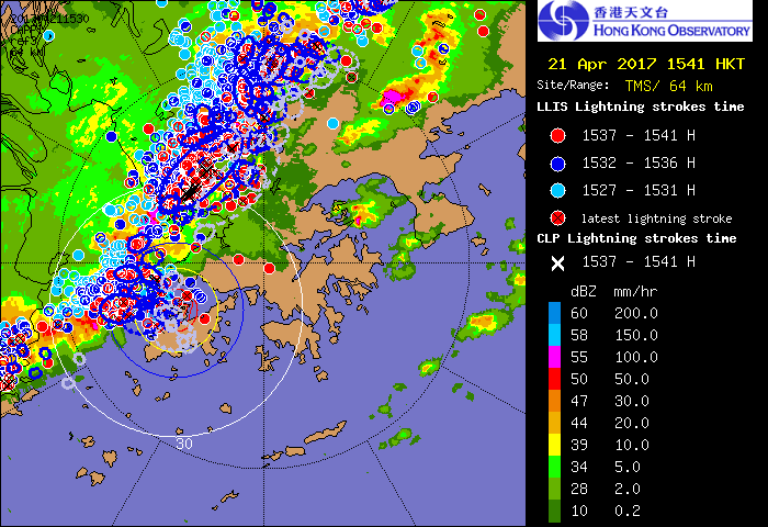
Lightning alerts from ATLAS at 15:41 on 2017/04/21 (HKT)
|