

Satellite Derived Reflectivity
|
An algorithm was developed to retrieve equivalent radar reflectivity from the Himawari-8 satellite of Japan Meteorological Agency with a view to enhancing precipitation nowcasting. Using several spectral bands of the Advanced Himawari Imager (AHI) onboard Himawari-8, two-dimensional equivalent radar reflectivity is derived using artificial neural network (ANN) based on past radar reflectivity data from a radar station in Hong Kong. Verification with a year of data shows that satellite derived reflectivity achieves a probability of detection over 70% at 24 dBZ threshold and over 40% at 33 dBZ threshold during daytime.

Simulated radar reflectivity from Himawari-8 during the passage of Super Typhoon Hato
Reference: Enhancements of the retrieval algorithm were implemented to improve its performance in recognizing significant convection. The satellite derived reflectivity are generated every 10 minutes followed by applying optical flow tracking algorithm to obtain the motion field and generate real-time significant convection (SigConv) nowcast overlaid with global lightning data in this page. Reference: |
NWC SAF/GEO
|
The EUMETSAT “Satellite Application Facilities” (SAF) on Support to Nowcasting and Very Short Range Forecasting for geostationary meteorological satellites (NWC SAF/GEO) has been implemented using the Advanced Himawari Imager (AHI) data of the Himawari-8/9 satellite of the Japan Meteorological Agency. A suite of NWC SAF/GEO nowcast products including cloud types and cloud top analyses, Convective Initiation (CI), Rapidly Developing Thunderstorm (RDT), Cloud Microphysics (CMIC), High Resolution Wind (HRW) and Convective Rainfall Rate (CRR/CRR-Ph) are developed for reference by forecasters in monitoring initiation and development of convective weather systems. Additionally, rapidly-update upper-air wind analysis based on inputs from HRW data are generated to delineate synoptic and mesoscale flow disturbances, as well as environmental steering flow, vertical wind shear and divergence for nowcasting tropical cyclone development.
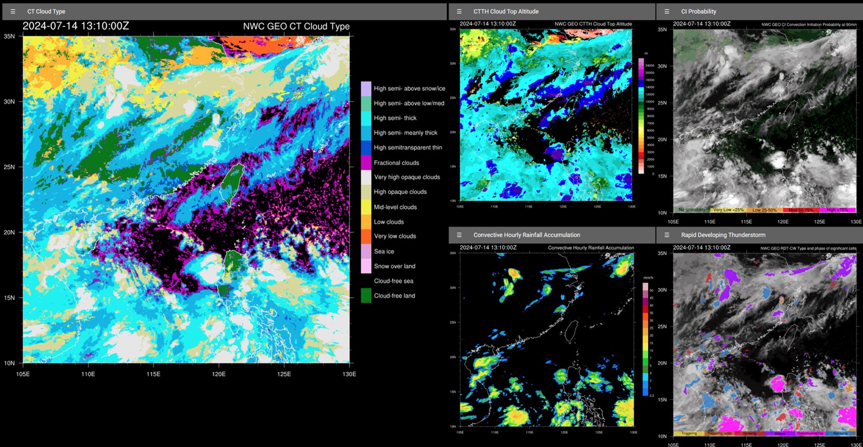
NWC SAF analysis products of cloud type, cloud top altitude, convective initiation (CI) probability, convective hourly rainfall accumulation and rapidly developing thunderstorm
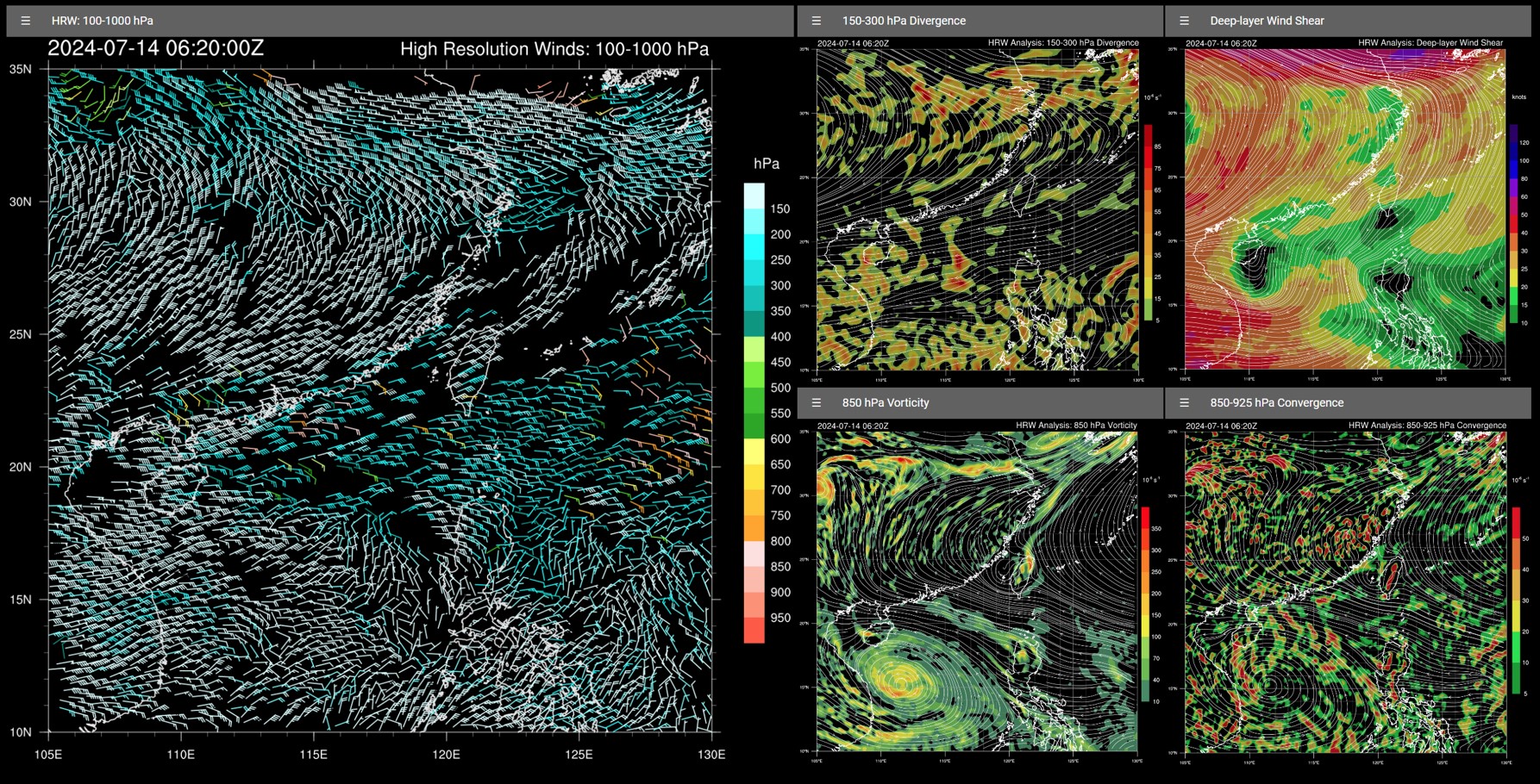
NWC SAF high resolution winds (left). The derived upper-air wind analysis products on upper-tropospheric divergence, deep-layer wind shear, low-level vorticity and convergence are shown on the right panels.
Reference: Wong, W. K. & He, Y. H. (2021): Development of NWC SAF/GEO in Nowcasting Significant Convective Weather in southern China, EUMETSAT Meteorological Satellite Conference 2021, 20-24 September 2021 Wong, W. K. (2020): Development of NWC SAF/GEO in support of severe weather nowcasting in the Hong Kong Observatory, NWCSAF CDOP3 Users’ Workshop, 12 March 2020 |